The Greenpoint / Williamsburg portion of the
Brooklyn Waterfront Greenway has taken root, with new parking restrictions and bike lane markings along a 1.7 mile section of Franklin Street and Kent Avenue from Quay Street to the Brooklyn Navy Yard.
On-street parking along both sides of the heavily-traveled stretch of Kent Avenue gave way to über-restrictive red "No Stopping" signs in the wee hours of October 25th. The unannounced Saturday change resulted a slew of parking tickets (and vocal outrage) on the Southside, where orthodox Jews were
unable to move their cars while observing the Shabbos.
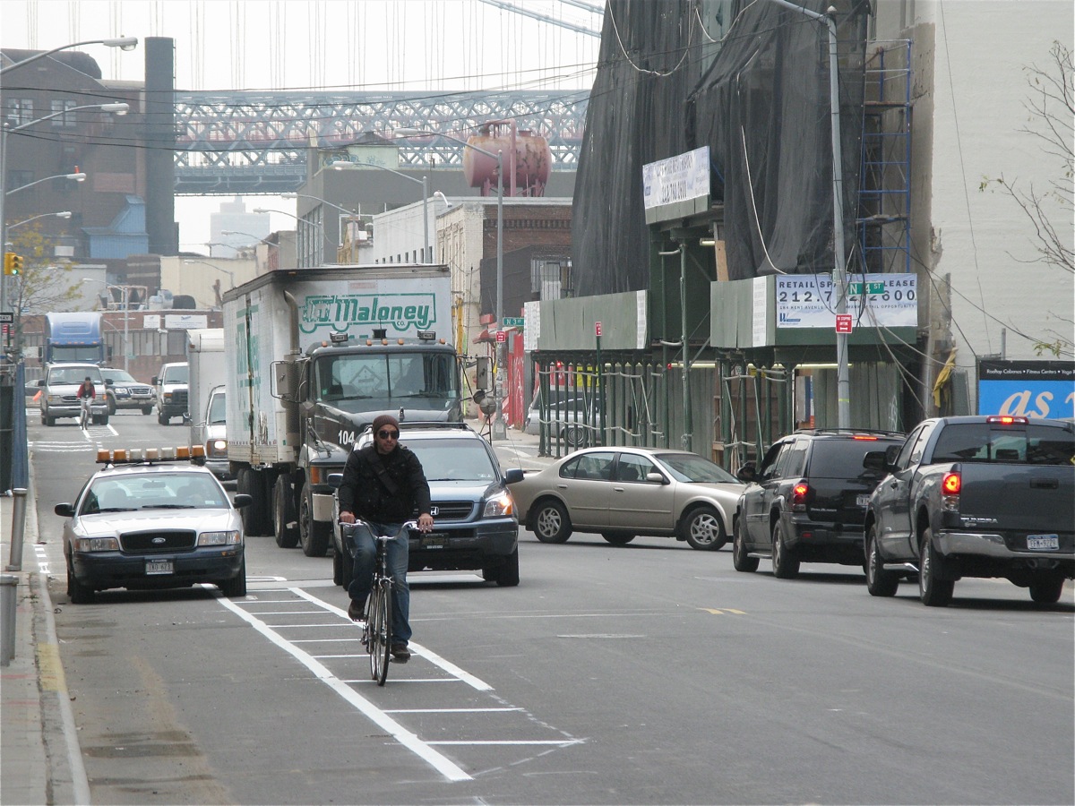
The new lanes are still being striped as we post, but in general the interim bikeway consists of a 68" wide bike lane on both sides of Kent Avenue with a 38 - 40" hashed 'no man's land' separating the cycling and vehicle lanes. At the curve between North 12th and North 14th, the bike lanes squeeze down to 56" with a 28" buffer, to allow an enlarged separation between the north and southbound driving lanes - where drivers typically take the inside of the curve - which would now mean running over cyclists in the new southbound bike lane.
At Quay Street in Greenpoint, the bikeway reverts to existing shared car/cycle lanes, with bike route symbols stenciled in both driving lanes of Franklin Street, north to Eagle. Our understanding is that eventually the Greenway will route a block west to West Street between Quay and Eagle, but no sign of that happening as part of the immediate changes.
While this is all great news for cyclists commuting from Greenpoint and the Northside to the Williamsburg Bridge (and a change we vocally advocated at the 2007 Greenway Design Workshop), it also opens up a veritable smorgasbord of canned worms:
1. Speeding cars and trucks. By eliminating two dozen blocks of on-street parking, the 'no stopping' signs effectively double the width of open pavement, creating a psychological Autobahn for drivers. Studies have shown that the wider the open road, the faster we drive on it - and white pavement stripes just aren't the same threat to your own vehicle as a row of parked cars.
While the new real estate is a relief for cyclists used to being squeezed between careening garbage trucks and parked rearview mirrors, at least in the old days cars and trucks were frequently forced to slow down to negotiate their way around double-parked delivery trucks and protruding construction equipment, so the average speed on Kent was relatively slow. Now, with acres of open pavement in all directions, drivers are emulating Jeff Gordon on the straightaway at Talledega, and any accidents are likely to be all the more spectacular (and tragic).
When we voiced our support for the interim bikeway (over the opposing "lets wait 'til we can build the Greenway on the river's edge" viewpoint), we recommended a 'soft' barricade be provided: a row of breakaway plastic posts, or plastic Jersey barriers, creating a double-width bikeway on the west side only, with warning signage for both bikers and drivers, wherever vehicles are able to cross to the west side of Kent Avenue (much like the West Side Highway bike path in Manhattan).
2. Neighborhood parking. Politically incorect as it may be, we have a vehicle for our business. And parking on the Northside has gone from perhaps the best in the city (dead ends at the river with parking on both sides, all day, every day) - to virtually nonexistant. First went the dead-ends at North 5th, North 6th and North 7th, deeded to the developers for use in their private residential complexes. Then came construction workers by the dozens if not hundreds, nearly all driving and parking on waterfront blocks every morning. Then the 'no standing' regulations on nearly every block of Kent Avenue from North 3rd to North 9th. But there was still the fallback of reliable spaces north of North 10th, if you didn't mind a bit of a hike, and leaving your vehicle in a virtual no-mans land at night.
The Greenway advocates reassured neighborhood car owners at the design summit by assuring them that parking spaces lost to the bike lanes would be replaced by parking structures built under the new high-rises; and by on-street spaces in front of commercial properties - currently restricted during business hours - reverting to regular all-day parking - as the commercial properties were converted to residential buildings.
So far, only Northside Piers has contributed new parking spaces to the neighborhood, and while $400 per month may be a deal compared to off-street options in Manhattan, its a big pill to swallow for residents used to free on-street parking.
3. Enforcement. Since the "no stopping" placards went up, it appears there's an invisible caveat hidden somewhere on the red signs: "NO STOPPING
(except for trucks, construction vehicles, and lunch wagons)". The only way the bike lanes work is if vehicles stay clear of them. Take a quick glance up and down Kent Avenue from North 6th, any time between 7 am and 5 pm weekdays, and you're sure to see a half-dozen or more delivery trucks, flatbed trailers delivering steel or prefab concrete, etc. Cyclists are forced to weave back and forth onto the and off of the Autobahn to get around them - creating a situation that's potentially more dangerous than when they puttered alongside parked cars, in plain sight of slower-moving drivers.
--
We don't mean to look a gift horse in the mouth here. Despite the new 20-minute parking adventure most days, we are also long-time bikers and strong advocates of cycling. And any step toward a real Brooklyn Waterfront Greenway is a step in the right direction.


